Motorcycling Across Pennsylvania
Originally published: 2010-07-06
Last updated: 2010-07-06
For much of my motorcycling life, I thought of Pennsylvania as an obstacle. Whether it was the bad pavement and heavy truck traffic of I-78 and I-81 between me and the Blue Ridge Parkway, or the long and lonely expanse of I-80 between me and home, I dreaded the state. It certainly didn't help matters that most of my rides across it were in the summertime, with oppressive heat and humidity, and the threat of a thunderstorm to keep me wearing an impermeable rainsuit. I'm writing these words on the morning of just such a day, and am actually thankful to be heading to work.
Now I live in Philadelphia, and either I ride through Pennsylvania or a I don't ride. And while I've found fun riding nearby, I'm still faced with the question of “how do I get there” if I want to head to the south or west. The problem is one of topography, compounded by road builders: it's hard to find east-west roads that aren't highways. Heading out of Philadelphia, it's hard to find east-west roads period; everything seems to be at a diagonal. I'm not sure if this was a result of surveyors starting at the Delaware river, or some part of William Penn's master plan, but it means that any trip involves a lot of zig-zagging.
Escaping the Megalopolis
And any trip starts with getting out of the Philadelphia metropolitan region — part of the greatest concentration of people in the United States. All of those people need places to live, meaning that the suburbs have been expanding outward in a maze of sub-divisions and Saturday traffic. Fortunately, Philadelphia has retained at least some of its rural hinterland — there's a 500 acre working farm less than three miles from my house in the northwest section of the city.
Which means that there are semi-rural roads that can get you out of the area. Two that I particularly like are PA-73 from the Plymouth Meeting area northwest to just north of Reading, and PA-926 from east of West Chester southwest to north of Oxford (which is in turn just north of the Maryland state line). Both of these roads have seen a lot of suburban sprawl in just the eight years that I've lived in the area, but I still think they're better than the alternatives. Unfortunately, they don't take you that far away from the city.
Crossing the Susquehanna
Heading west, after you get out of the city and through the farmlands of
Lancaster county you reach your next obstacle: the
Susquehanna river It rises in upstate New York, and empties into the top of the Chesapeake Bay.
Near its source,
it's no more than a dozen miles from the Delaware River. If you travel any
distance north or west from Philadelphia, you have to cross it. Unfortunately
for those going west, there are only eight crossings in the nearly 100 miles
between Harrisburg and the Chesapeake: three of them are interstate highways,
three are federal highways, and one of the remaining two is a congested local
road that parallels a US highway.

If you're heading to the south, I think that US-1 is the best crossing. Not only do you get to ride over an operating hydro-electric dam , but most traffic sticks to nearby I-95. The only problem with US-1 is that it quickly enters the nightmare of Baltimore and Washington DC. There is a patchwork of roads to the west that are signed as the “Mason and Dixon” scenic byway, which lead to the Catoctin Mountains of western Maryland. It's a long day's ride, with a lot of turns and small towns, but avoids exurban traffic.
The second best south-of-Harrisburg crossing is PA-372, particularly since the eastern section passes through quiet Lancaster County farmland (avoiding the tourist hell that is US-30). However, PA-372 runs into the same problem of no clear path westward once you cross the Susquehanna, and a wrong turn will take you into York.
And that's something you want to avoid at all costs. My feelings toward York were formed years ago, on a hot day, when I had an infected finger on my clutch hand. Those feelings haven't changed since: I think I can safely say that I've never had an enjoyable motorcycle ride that passed near that city. There's an enormous amount of traffic, compounded by lots of traffic lights. Given the choice, I'll get on the Turnpike every time.
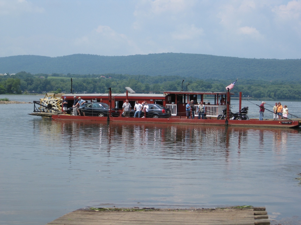
Millersburg Ferry
Even if your destination is south, an alternative is to cross the river north
of Harrisburg. The bridges are more plentiful, and the traffic is generally
lighter. And then there's the
Millersburg ferry.
It's the only ferry on the Susquehanna, and definitely takes more time than
the nearest bridges, but it's an experience not to be missed. Call beforehand,
however, as it only runs during the summertime, and only when the water is
high enough.
Millersburg is at the western terminus of US-209, a road that I generally try to avoid: it passes through a lot of small towns and always seems to be crowded. PA-25 to the north, or PA-225 to the south are both more pleasant.
If you leave the Philadelphia region in the morning and stick to backroads, you'll get to Millersburg around lunchtime. I've eaten several times at the Wooden Nickel, on the town square. It's a “family style” restaurant, reasonably priced, and I have no complaints. As far as I can tell it's the best restaurant between Harrisburg and Selinsgrove.
The ferry landing is just north of the town square — and the word “landing” is appropriate: you ride down onto the gravel riverbank, then up a wooden ramp onto the ferry. The ferry itself resembles a houseboat with a big paddlewheel behind and a barge lashed to its side; it will fit a couple of cars or a dozen motorcycles. As you head out into the river, you'll realize that the paddlewheel isn't decorative, it's the only source of forward motion. This is about the same time that you'll notice the rock ledges immediately upstream and downstream. The only thing keeping you safe is the skill of the captain, and on a day with high water and a strong current he won't be very talkative.
The western ferry landing is at a campground (which I think is owned by the ferry operator); it's a good place to stop for a restroom break. US-15 and US-11 run together along the west shore. They'll take you up to Selinsgrove, home of the Selin's Grove Brewing Company and other restaurants, but it's a high-traffic multi-lane highway. A better option is to take one of the smaller state roads that head generally west, toward the central PA mountains.
Through the Mountains
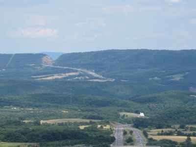
Mountains are usually a motorcyclist's friend: think of the Blue Ridge Parkway, US-50 through West Virginia, or US-34 through Rocky Mountain National park, and ask yourself what they'd be without mountains to wrap around. Pennsylvania's central mountains (which run into the Maryland panhandle), while formed at the same time as the Blue Ridge, have a very different shape: they're long ridges with valleys between, and very few gaps. And unfortunately for the motorcyclist, the roads through those gaps tend to be highways.
If you have the time for long zig-zags, however, the valleys make for some pleasant riding. And they close in at their southwest point, meaning you'll get to ride twisties up and over to the next valley. For example, just north of the west-shore Millersburg ferry landing is PA-34, which will take you west to Newport. There you pick up PA-849 to PA-74, which takes you up Tuscarora Mountain and into the next valley. Then PA-75 southwest to PA-850, which takes you over some small ridges to PA-35. The valleys are rural farm country, then the road rises up through mostly unpopulated woodlands (often state land) on the flanks of the mountains.
The main problem with these routes is keeping track of them. The preceding litany of numbered roads seems straightforward enough, but I composed it while looking at Google Maps, based on my memories of a ride from last summer. Trying to puzzle a route out of the small type and fine lines of a AAA map sitting on your tankbag is a lot more difficult. You might find yourself on a road that starts out pointing west but ends up pointing east. But that's half the fun, right? If you want a guarantee, take the Turnpike.
The Juniata River
Rivers find their own way through mountains, and roads follow. In the case of the Juniata, the route starts a dozen or so miles north of Harrisburg, heads north to skirt Tuscarora Mountain, west to a gap through Blue Mountain, southwest to a gap through Jack's Mountain, then south (as the Raystown branch) to Bedford county. The corresponding road for much of this length is US-22, which is nobody's idea of a good motorcycling road.
Fortunately, US-22 isn't the only road that runs along the river. PA-333 follows the west bank of the river from somewhat west of Millerstown (not Millersburg, and if you click the link you want the secondary road that Google won't include in the route). In Juniata Terrance it meets PA-103, which follows the river south. I've only taken this route once, but have memories of an empty road clinging to the side of a mountain, with a steep drop down to the river and the old Pennsylvania Railroad mainline. Across the river you can see cars zooming up the limited-access stretch of US-22, oblivious to the scenery around them.
PA-103 ends in Mt Union, and my memories of it are less desirable: Friday afternoon traffic heading to Raystown Lake for the weekend. The alternative (which I haven't yet tried) seems to be PA-747 south to PA-994.
Destination: Bedford
If you've taken the routes suggested above, chances are good that you've spent most of the day riding and haven't yet left Pennsylvania. And if you've been following the Juniata river, you're probably in Bedford, which sits just off the turnpike in the foothills of the Allegheny mountains. From Bedford, you can take US-220 south into the Maryland panhandle and West Virginia, or US-30 (the Lincoln Highway) west to Ohio and points beyond. But Bedford itself is a great destination, especially if you only have a weekend.
The main reason is that it's at the nexus of several great roads:
PA-56 north to Johnstown,
PA-96 south into Maryland west of Cumberland, and
PA-26,
which road runs from nearby Everett PA south into Maryland and meets up with
WV-51 just outside Paw Paw. For a history geek, particularly a railroad
history geek, each direction offers something: to the north lie the remains
of the
Allegheny portage railroad and the still-active
horseshoe curve;
the south offers the
Western Maryland scenic railway and the
Paw Paw tunnel;
and to the east is the tiny (and rarely open)
Everett railway museum.
You can make a nice loop starting on PA-56, which runs through farmland to
Pleasantville, then up over a ridge into the Gallitzin state forest. After
the forest, you enter the town of Windber, formerly a “company town”
owned by the Berwind-White coal company. The downtown has been the target of
revitalization grants, giving it a coal mining museum / interpretive center
and renovating the downtown hotel as a restaurant with a decent burger and a
great beer list.
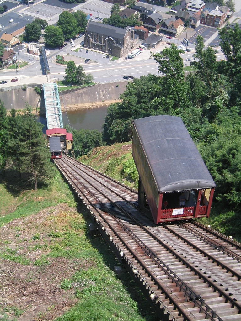
It's a short ride from Windber to Johnstown, site of the famous flood. I recommend taking a ride on the incline: a funicular railway that rises 500 feet above the city proper, built after the flood to enable residential construction on higher ground — and you can take your motorcycle with you. From the top, you can look northeast along the path of the Conemaugh river, and easily picture a wall of water crashing into the town. About ten miles northeast of the city is the National Park Service visitor center at the site of the South Fork dam, which caused the flood. Today, all that's left of the dam is a gap in the hills with railroad tracks running through it.
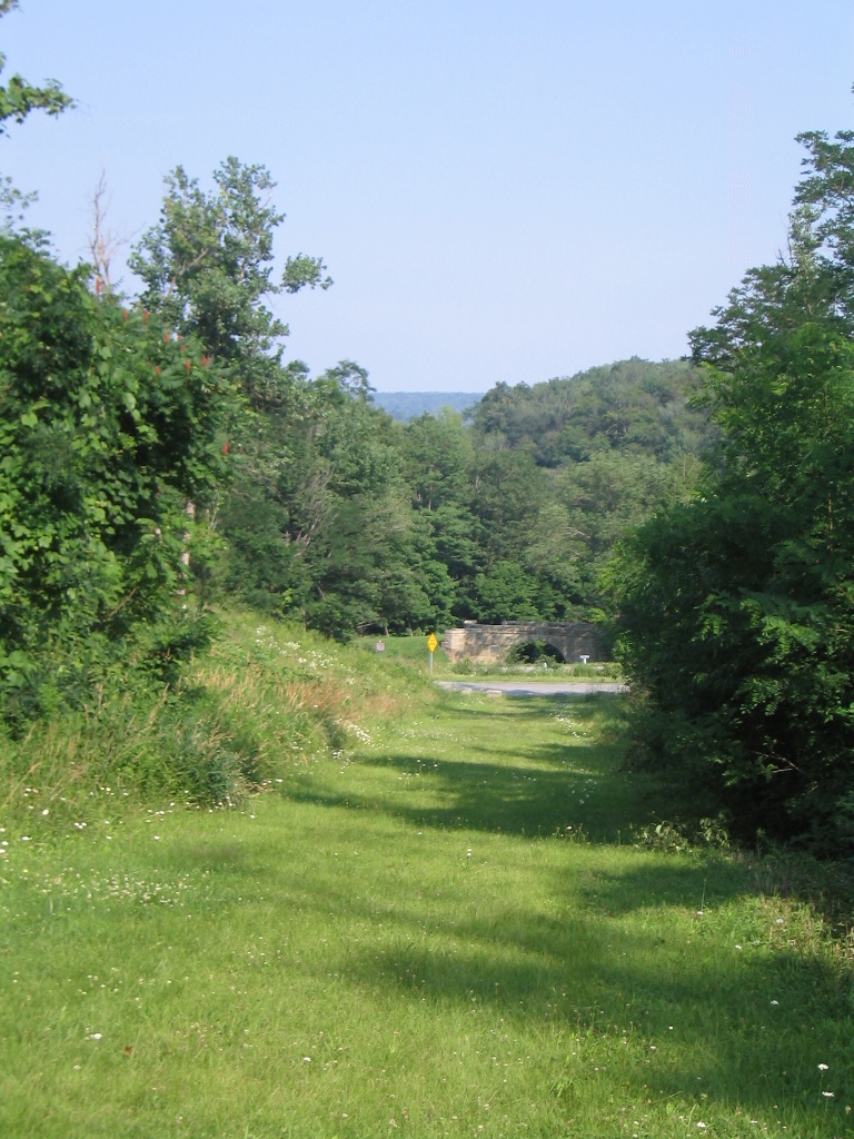
From the South Fork dam, PA-53 will take you northeast to another Park Service site commemorating something that no longer exists: the Allegheny Portage Railroad. Created in the early 1800s as part of the Main Line of Public Works, the portage railroad used stationary steam engines to haul canal boats over the Allegheny ridge on railroad cars. The visitors center features a reconstructed power house sitting atop a break in the forest where once there was an incline. At the bottom of the incline slope, you can see a stone bridge that once carried a road over the railway, next to the modern (and very much active) US-22.
The Main Line of Public Works was sold to the Pennsylvania Railroad in the 1850s. Continuing north on PA-53, you'll see the railroad's approach to getting freight and people across the Alleghenies: a tunnel through the mountain. The tunnel was only part of the solution: the Horseshoe Curve, a long switchback on the eastern side of the ridge, was the other. The curve is still in operation, and there's a staircase to an observation area where you can watch mile-long freight trains slowly ascending or descending; you'll almost certainly find a railfan with a radio standing there who can tell you when the next train is due. To get to the horseshoe curve from Gallitzin, leave town on Tunnel Hill street, then take a right on Glenwhite road, which follows a creek downhill. I recall signage, but suggest that you print this map or bring a GPS (Google doesn't show Glenwhite Road connecting to the vistor center, but I've ridden it).
From Altoona, US-220 (I-99) is a straight shot back to Bedford. But if you still have daylight, there are plenty of nearby roads that are more pleasant.
Food and Lodging
If the foregoing trip description gave you the idea that there's not much
happening in Bedford itself, well, you'd be half-right. Downtown Bedford is
a great place to walk, especially if you like 19th-century architecture or
Colonial-era fortifications.
To the north is a
living history museum (never been there), to the west a
state park,
and there's even a nearby
limestone cavern;
the Bedford County Visitors Bureau will tell you all about them. But for a motorcyclist, these things are just
distractions — and
Gravity hill is more than a bit dangerous on a motorcycle.
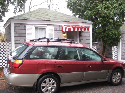
The reason that I picked Bedford as a destination is that it provides the most options for food and lodging, without being overly urbanized. Lodging runs the gamut from chain hotels at the turnpike exit, to the quirky Lincoln Motor Court (pictured right, with my car in front of our cabin for scale), to B&Bs, to the money-is-no-object Bedford Springs resort. Food runs a similar range, although the downtown restaurants have limited hours.
One place that I like for both food and lodging is the Jean Bonnet Tavern, just west of town. It's a late-1700s inn that has one of the better (casual) restaurants in the area, with a truly exceptional beer list. They also have four rooms that manage to combine colonial feel (uneven wide plank floors, four-poster beds) with modern plumbing. My wife and I have eaten there many times, and stayed there twice; it's nice to just climb two flights of stairs part after sampling the exceptional beer list.
A final benefit of Bedford for the motorcyclist is its proximity to the turnpike: if you find yourself running the back roads until late on Sunday, it's only 3½ hours back to Philadelphia.
Copyright © Keith D Gregory, all rights reserved